Table of Contents
Q) What are Sagar Tara and Sagar Anveshika a type of?
A.Arctic expedition
B.Coastal research vessel
C.Marine observatory
D.Antarctic research station
The acquisition of the two Coastal Research Vessels is carried out by Ministry of Earth Sciences (MoES) through National Institute of Ocean Technology (NIOT), an autonomous institute under MoES.
- Manufactured by Titagarh Wagons Ltd (TWL) Shipyard, Kolkata
- Coastal Research Vessel :- SAGAR TARA and Sagar Anveshika.
- Equipped with the advanced scientific equipment and latest navigational equipment with a role of measuring oceanographic and atmospheric data within the Exclusive Economic Zone [EEZ] of India.
- Other scientific research vessels of MoES viz. Sagar Kanya, Sagar Samapada, Sagar Nidhi, Sagar Manjusha and Sagar Purvi.
- This ship will also be utilized for :-
- shallow water operations [Surface Water Quality Monitoring (SWQM).
- shallow water testing of various underwater components.
- technology demonstration.
- Tsunami early warning systems.
- Deep sea technology development.
- Drugs from sea.
- Bathymetry survey of Exclusive Economic Zone [EEZ].
- Environmental indexing of ships and coastal zones.
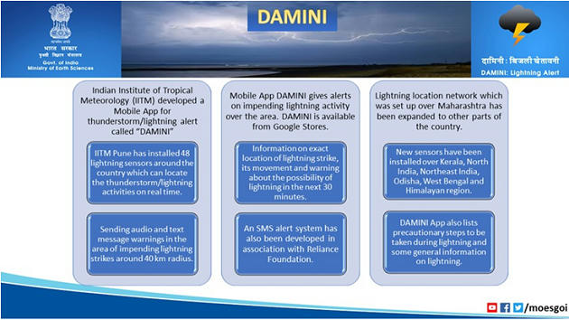
SAFAR ::
- The System of Air Quality and Weather Forecasting And Research (SAFAR) is a national initiative introduced by the Ministry of Earth Sciences (MoES) to measure the air quality of a metropolitan city, by measuring the overall pollution level and the location-specific air quality of the city.
- The system is indigenously developed by the Indian Institute of Tropical Meteorology (IITM), Pune and is operationalized by the India Meteorological Department (IMD).
- It has a giant true color LED display that gives out real-time air quality index on a 24×7 basis with color-coding (along with 72 hours advance forecast). The ultimate objective of the project is to increase awareness among the general public regarding the air quality in their city so that appropriate mitigation measures and systematic action can be taken up.
- SAFAR is an integral part of India’s first Air Quality Early Warning System operational in Delhi.
- It monitors all weather parameters like temperature, rainfall, humidity, wind speed, and wind direction, UV radiation, and solar radiation. Pollutants monitored: PM2.5, PM10, Ozone, Carbon Monoxide (CO), Nitrogen Oxides (NOx), Sulfur Dioxide (SO2), Benzene, Toluene, Xylene, and Mercury.
Schemes of Ministry of Earth Sciences
- O-Smart
- HPC & GEPS
- Gramin Krishi Mausam Seva
- Sagar Vani & India Quake
- ACROSS scheme
Q) Consider the following statements
- Meghdoot mobile app is a joint initiative of the Ministry of Earth Sciences and the Ministry of Agriculture
- India Meteorological Department works under the ministry of Science & Technology
Options :
- Both A & B are correct
- Only A is correct
- Only B is correct
- Neither of the two is correct
Gramin Krishi Mausam Seva ::
- Under Gramin Krishi Mausam Sewa project (GKMS), India Meteorological Department (Ministry of Earth Science) in collaboration with State Agricultural Universities /Indian Council of Agricultural Research etc. is issuing crop and location specific weather based agro advisories for the benefit of farming community on every Tuesday and Friday and occurrence of extreme weather.
- At present, the GKMS are disseminated to 40 million farmers.
- Different media like print/visual/Radio/ IT based including SMS & IVRS for a wider dissemination.
- Maximum temperature.
- Minimum temperature.
- Wind speed.
- Wind direction.
- Relative humidity.
- Weekly cumulative rainfall forecast.
- Crop specific agro meteorological advisories.
Sagar Vani & India Quake ::
- Ministry of Earth Science launched two mobile apps
- ‘India Quake’ for the dissemination of earthquake parameters
- ‘Sagar Vani’ to disseminate ocean information and alerts to the user community in a timely manner
- Sagar Vani :-
- It is a software platform where several dissemination modes will be incorporated into a single central The ‘Sagar Vani’ includes Voice Call, Multi Lingual SMS, Audio Advisory, Mobile Apps (User / Admin modules), Social Media (Twitter, Facebook, etc.), GTS, Email, Digital Display Boards, Fax, IVRS, Radio and Television transmission units, Cloud Channels, etc.
- Sagar Vani also has the capability to give access to di”erent stakeholders such as the State Fisheries department, NGOs, Disaster Management Authorities, and others so that they also shall be able to further circulate these alerts and ocean information to the community of users.
- This ‘Sagar Vani’ system matches servers used in the developed countries in terms of delivery speed and omni channel capabilities. It is also high on diversity of services. The services will be dispersed in local languages.
- The fisheries and aquaculture production contributes around 1% to India’s Gross Domestic Product (GDP) and over 5% to the agricultural GDP
- ESSO-Indian National Centre for Ocean Information Services (INCOIS) under Ministry of Earth Sciences (MoES) provides ocean information services
- HQ – Hyderabad
- Founded – 1999
- Potential Fishing Zone (PFZ)
- Tsunami Early Warning System (TEWS)
- Ocean State Forecast (OSF)
- Ocean Observation Group (OOG) – measure and monitor the surface temperature and salinity of the upper 2000 meters of the ocean.
India Quake :-
- The Mobile App is developed by the National Centre for Seismology launches
- It is an App for Earthquake Parameter Dissemination (location, time and magnitude) after the occurrence of earthquakes.
- It will aid in decreasing alarm and panic amid people during an earthquake. For example, if an earthquake occurs in Hindukush region which is in Afghanistan but is intensely felt in Haryana, then the people residing in Haryana will know within minutes that the disaster has really happened in Afghanistan and not in Haryana.
O-Smart ::
- Umbrella scheme “Ocean Services, Technology, Observations, Resources Modelling and Science (O-SMART)” of Ministry of Earth Sciences
- Time period from 2017-18 to 2019-20 at an overall cost of Rs.1623 crore.
- The scheme encompasses a total of 16 sub-projects addressing ocean development activities such as Services, Technology, Resources, Observations and Science.
- The services rendered under the O-SMART will provide economic benefits to a number of user communities in the coastal and ocean sectors, namely, fisheries, o”shore industry, coastal states, Defence, Shipping, Ports etc.
- Sustainable Development Goal-14, aims to conserve use of oceans, marine resources for sustainable
- This scheme (O-SMART) also provide necessary scientific and technological background required for implementation of various aspects of Blue Economy.
- The State of Art Early Warning Systems established under the O-SMART Scheme will help in e”ectively dealing with ocean disasters like Tsunami, storm surges. The technologies being developed under this Scheme will help in harnessing the vast ocean resources of both living and non-living resources from the seas around India.
The important deliverables during the next 2 years envisage include
- strengthening of Ocean Observations and Modelling
- Strengthening of Ocean Services for Fishermen
- setting up Marine Coastal Observatories for monitoring marine pollution
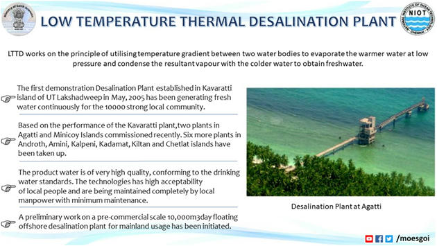
- setting up Ocean Thermal Energy Conversion Plant (OTEC) in Kavaratti
- acquisition of 2 Coastal Research Vessels for Coastal research
- Continuation of Ocean Survey and Exploration of Minerals and Living Resources
- Technology Development for Deep Ocean Mining- Deep Mining System and Manned Submersibles
- setting up Six Desalination Plants in Lakshadweep
Q) Consider the following statements about Deep Ocean Mission
- 75,000 sq km of international waters has been allocated by UNCLOS to India
- India aims to mine Polymetallic nodules that are also called magnesium nodules
Options :
1.) Both A & B are correct
2.) Only A is correct
3.) Only B is correct
4.) Neither of the two is correct
Deep Ocean Mission ::
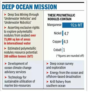
- Central Indian Ocean Basin (CIOB)
- India has exclusive rights over 75,000 sq km of international waters, allocated by UN’s International Seabed Authority, for exploration of polymetallic nodules.
- Merits of Deep-Sea Mission
- Commerce, important metals (manganese, copper, nickel, cobalt etc)
- These metals can be extracted and used in electronic devices, smartphones, batteries and even for solar
- Better understand Underwater robotics and vehicles
- It can open up new sources for medical drugs and food
- 10% recovery of ocean resources can meet India’s energy requirement for 100 years
- Challenges
- Financial (viable only if 3 million tonnes/year is explored
- Sediment plumes can harm aquatic animals
- Noise pollution inside ocean
ACROSS Scheme ::
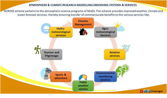
- “Atmosphere & Climate Research-Modelling Observing Systems & Services (ACROSS)”.
- Implementation period – 2017-2020.
- The scheme aims at improving skill of weather and climate forecast through sustained observations, intensive Research & Development.
- It seeks to addresses di”erent aspects of weather and climate services, which includes warnings for cyclone, storm surges, heat waves, thunderstorms.
- Each of these aspects is incorporated as nine sub-schemes under the umbrella scheme “ACROSS” and is implemented in an integrated manner through the aforesaid four institutes.
- It will be implemented by the Ministry of Earth Sciences through its institutes namely
- India Meteorological Department (IMD)
- Indian Institute of Tropical Meteorology (IITM)
- National Centre for Medium Range Weather Forecasting (NCMRWF)
- Indian National Centre for Ocean Information Service(INCOIS)
Q) Which of the following pairs is correctly matched
- Pratyush – Indian Institute of Tropical Meteorology (IITM)
- Mihir – National Centre for Medium-Range Weather Forecasting (NCMRWF) SERC-Cray – Indian Institute of Science
Options :
1.) B & C
2.) Only A
3.) Only B
4.) A, B & C
HPC & GEPS ::
- High performance computing units, Pratyush.
- India’s fastest and first multi-petaflops (PF) supercomputer named Pratyush was unveiled at Pune-based Indian Institute of Tropical Meteorology (IITM).
- The supercomputer has been named as ‘Pratyush’ meaning Sun.
- Pratyush has 4.0 Peta Flops HPC facility at IITM, Pune.
- Mihir has 2.8 Peta Flops facility at NCMRWF, Noida.
- Both are dedicated for weather and climate research.
- 8 Peta Flops (PF) capacity High Performance Computer (HPC) system named ‘Mihir’, at the National Centre for Medium Range Weather Forecasting (NCMRWF)
- Pratyush is the fourth fastest supercomputer in the world dedicated for weather and climate research.
- India’s first supercomputer called PARAM 8000 was launched in 1991
- PM Modi recently launched the supercomputer Param Shivay of 833 teraflop capacity built at the IIT-BHU.
Government Scheme | Free PDF



 WhatsApp