Table of Contents

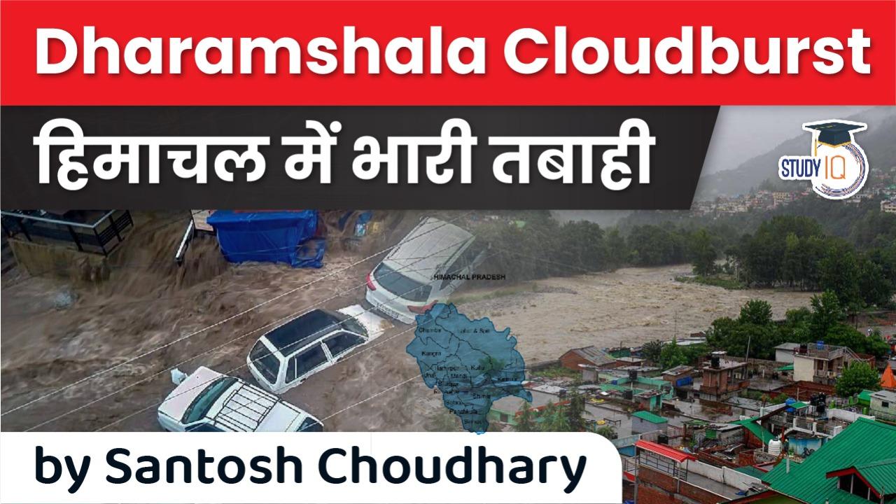
Cloudburst in Himachal Pradesh triggers flash floods in Dharamshala
- Flash floods were reported in Bhagsu Nag, Dharamshala district of Himachal Pradesh due to heavy rainfall.
- The monsoon is wreaking havoc in Himachal Pradesh and Uttarakhand as flash floods, landslides were being reported.
- Also , A cloudburst over Ganderbal district of Jammu and Kashmir damaged the highway, caused damage to residential properties, and triggered flash floods in the area.
- Major damage was reported at the site of the incident in Watlar area of Lar in Ganderbal.

- As the southwest monsoon continues to elude Delhi, Punjab and Haryana, it is wreaking havoc in parts of Himachal Pradesh and Uttarakhand.
- In Himachal Pradesh’s Dharamshala, flood waters swept through the streets of Bhagsu Nag village, damaging parked vehicles.

- There is an orange weather alert on Monday and Tuesday (12 July and 13 July) for heavy to very heavy rains in plains and mid-hills.
- The India Meteorological Department (IMD) has also issued a yellow weather alert for 14 July and 15 July.
- According to a report, two people went missing in the Kangra flash floods.
- While there are flash floods in Himachal Pradesh, 30 people have been killed in the states of Rajasthan and Uttar Pradesh due to incidents of lightning.
- It has also been reported that ex-gratia of Rs 2 lakh each for the kin of the victims has been announced by Prime Minister Narendra Modi.

What is Cloud Brust?
- A cloudburst is short-term extreme precipitation that takes place over a small area; it is not, as is sometimes understood, the breaking open of a cloud resulting in the release of huge amounts of water.
- Cloudbursts have a very specific definition: if rainfall of about 10 cm or above per hour is recorded over a place that is roughly 10 km x 10 km in area, it is classified as a cloudburst event.
- And by this definition, 5 cm of rainfall in half an hour would also be classified as a cloudburst.
- To put this in perspective, India, in a normal year, gets about 116 cm of rain in the entire year: it means that every area in the country, on an average, should expect to get only this amount during the course of the year.
- A cloudburst would therefore account for 10-12 per cent of the annual rainfall of that area in just an hour!
WHY ,HOW AND WHERE !!
- Cloudbursts do happen in plains as well, but there is a greater probability of them occurring in mountainous zones; it has to do with the terrain. Cloudbursts happen when saturated clouds are unable to produce rain because of the upward movement of very warm current of air.
- Raindrops, instead of dropping down, are carried upwards by the air current. New drops are formed and existing raindrops gain in size.
- After a point, the raindrops become too heavy for the cloud to hold on to, and they drop down together in a quick flash.
- Hilly terrains aid in heated air currents rising vertically upwards, thereby, increasing the probability of a cloudburst situation.
- In addition, as pointed out earlier, cloudbursts get counted only when they result in largescale destruction of life and property, which happens mainly in mountainous regions.
Can cloudbursts be forecast?
- They are difficult to forecast but not impossible; the difficulty arises out of the fact that they take place over a very small area. Forecasts for a very small area are difficult to predict.
- But through the use of doppler radars, it is possible to forecast the possibility of cloudbursts about six hours in advance, sometimes even 12-14 hours in advance.
- Uttarakhand is highly prone to cloudburst events. Nineteen of the 30 major cloudburst events reported from the southern rim of the Himalayas occurred in Uttarakhand.
- In 2019, there was a cloudburst event in Chamoli district while there were a dozen of these events in 2018. But the official response to these events has been slow.
- In January 2021, the IMD and state government installed a doppler weather radar in Mukteshwar in Kumaon, which had been in the pipeline for many years.
- The reason for the installation is to predict cloudbursts and other extreme rainfall events, further generating alerts through early warning systems.
- The plans were set in place after the devastating Kedarnath cloud burst in 2013 that killed more than 5,000 people in the region.
- Doppler weather radars are ideal for near-real time tracking of potential cloud bursts. Especially if they have a network which allows them to track winds and moisture.
- The current radar is anywhere between 200-400 km away from the places where the recent cloudburst events have happened. Hence it was not of much help in predicting them.
- There are plans to install two more doppler weather radars in Dhanoulti, Tehri Garhwal district and Lansdowne, Pauri Garhwal district.
What is Flash Flood ?
- A flood caused by heavy or excessive rainfall in a short period of time, generally less than 6 hours.
- Flash floods are usually characterized by raging torrents after heavy rains (when rain falls so fast that the underlying ground cannot cope, or drain it away fast enough) that rip through river beds, urban streets, or mountain canyons sweeping everything before them.
- They can also occur even if no rain has fallen, for instance after a levee or dam has failed, or after a sudden release of water by a debris or ice jam.
- Roads can become like rivers and if there is a lot of water, it can flood buildings and carry cars away. So, if the rain is falling too fast for the ground or drains to cope, there is a risk of flash flooding.
What causes Flash Flood?
- Most rivers flow fairly gently as they slope slowly towards the sea. Therefore, when a river floods it does so quite slowly as it takes time for the rain to percolate through the ground and into the rivers and out to sea, allowing time for some warning.
- With flash flooding, there is often very little time between the rain falling and flash flooding occurring.
- Flash flooding commonly happens more where rivers are narrow and steep, so they flow more quickly. It can also occur from small rivers in built-up urban areas, where hard surfaces such as roads and concrete don’t let the water drain away into the ground.
- This leads to surface overflow and can often overwhelm local drainage systems, leading to flash flooding.

Latest Burning Issues | Free PDF


 WhatsApp