Table of Contents
Tributaries of Ganga
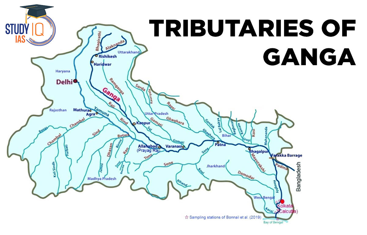
In terms of its basin and cultural significance, the Ganga is the most significant river in India. In Uttarakhand’s Uttarkashi district, close to Gaumukh (3,900 m), it emerges from the Gangotri glacier. It is referred to as the Bhagirathi here. The Ramganga, the Gomati, the Ghaghara, the Gandak, the Kosi, and the Mahanada are among the Ganga’s significant tributaries. Near Sagar Island, the river finally empties into the Bay of Bengal.
In terms of its basin and cultural significance, the Ganga is the most significant river in India. In Uttarakhand’s Uttarkashi district, close to Gaumukh (3,900 m), it emerges from the Gangotri glacier. It is referred to as the Bhagirathi here. It forms narrow canyons that slash through the Central and Lesser Himalayas. The Bhagirathi joins the Alaknanda near Devprayag, when it becomes known as the Ganga. The Satopanth glacier, located above Badrinath, is where the Alaknanda originates. The Dhauli and the Vishnu Ganga, which converge at Joshimath or Vishnu Prayag, make up the Alaknanda. The Pindar and other Alaknanda tributaries join it at Karna Prayag, and Mandakini or the Kali Ganga joins it at Rudra Prayag.
Before separating into two distributaries, the Bhagirathi and the Hugli, it runs from Haridwar first to the south, then to the south-east and east. The river is 2,525 kilometres long. Bihar (445 km), West Bengal, Uttar Pradesh (1,450 km), and Uttarakhand (110 km) all share it (520 km). In India alone, the Ganga basin spans an area of around 8.6 lakh sq. km. With several perennial and non-perennial rivers that originate in the Peninsula in the south and the Himalayas in the north, respectively, the Ganga river system is the largest in India.

Tributaries of Ganga River Map
Yamuna
The Yamunotri glacier, which is located on the western slopes of the Banderpunch range, is where the Ganga’s longest and most western tributary originates (6,316 km). At Prayag, it merges with the Ganga (Allahabad). Its left bank is joined by the Hindan, the Rind, the Sengar, the Varuna, etc., while its right bank is joined by the Chambal, the Sind, the Betwa, and the Ken, which come from the peninsular plateau. For irrigation purposes, a large portion of its water supplies the western, eastern, and Agra canals.
Chambal
The river flows through a gorge north of Kota, Rajasthan, where the Gandhisagar dam has been built, before rising close to Mhow in the Madhya Pradesh Malwa plateau. After travelling through Bundi, Sawai Madhopur, and Dholpur from Kota, it finally joins the Yamuna. The Chambal is well-known for the Chambal ravines, which are part of the badlands landscape.
Gandak
It consists of the Kaligandak and Trishulganga streams. Between Dhaulagiri and Mount Everest in the Nepal Himalayas, it begins to rise and drains the country’s heart. In Bihar’s Champaran district, it reaches the Ganga plain and meets the Ganga at Sonpur, close to Patna.
Ghaghara
It comes from the Mapchachungo glaciers. After gathering the water from its tributaries, the Tila, Seti, and Beri, it emerges through the mountain near Shishapani, carving a vast chasm. Before it eventually connects with the Ganga at Chhapra, the river Sarda (also known as Kali or Kali Ganga) joins it on the plain.
Kosi
The river’s main stream, the Arun, begins in Tibet to the north of Mount Everest, where it has its origin. The Son Kosi from the west and the Tamur Kosi from the east join it after traversing Nepal’s Central Himalayas. After joining the river Arun, it creates Sapt Kosi.
Ramganga
It is a rather minor river that rises in the Garhwal mountains close to Gairsain. After crossing the Shiwalik, it modifies its trajectory to the southwest and enters the plains of Uttar Pradesh close to Najibabad. Near Kannauj, it finally merges with the Ganga.
Damodar
It is located on the eastern edge of the Chotanagpur Plateau, flowing through a rift valley before merging with the Hugli.
Barakar
It is a major tributary to it. The Damodar, formerly referred to as the “sorrow of Bengal,” has been subdued by the Damodar Valley Corporation, a multipurpose project.
Sarda
The Goriganga, also known as the Sarda or Saryu River, originates in the Milan Glacier of the Nepal Himalayas. It is known as Kali or Chauk along the Indo-Nepal border, where it joins the Ghaghara.
Mahananda
Another significant Ganga tributary, it rises in the Darjeeling hills. As the final left bank tributary of West Bengal, it joins the Ganga.
Son
It is a significant Ganga River right bank tributary. It is a sizable Ganga tributary that rises on the plateau of Amarkantak. The river reaches Arrah, west of Patna, where it joins the Ganga after generating a string of waterfalls at the edge of the plateau.
Tributaries of Ganga Right Bank
- Yamuna River
- Chambal River
- Banas River
- Sind River
- Betwa River
- Ken River
- Son River
Tributaries of Ganga Left Bank
- Ramganga River
- Ghaghra River
- Kali River
- Gandak River
- Burhi Gandak
- Kosi River
Tributaries of Ganga UPSC
- On November 4, 2008, Indian Prime Minister Manmohan Singh proclaimed the Ganga River, often known as the Ganges River, to be the nation’s official river.
- The Ganga, a national river of India, passes through both India and Bangladesh. The Ganga Action Plan Phase-I was initiated in June 1985.
- The river discharges into the Bay of Bengal after passing through the Himalayas and the Gangetic plains.
- It is a widely held conviction that bathing in the Ganges River will wash away sins. It also channels salvation, according to Indian cultural beliefs.
- A custom of floating candles into the rivers while praying to Goddess Ganga is part of the Siamese holiday known as “Loy Krathong” in Thailand.
- The Gangotri Glacier is where the Bhagirathi River originates.
- The Ghagra River is the greatest tributary of the Ganga, and it originates from the Gangotri Glacier under the name Bhagirathi River.
- Along the Ganga River’s banks are numerous holy sites, including Gangotri, Haridwar, Prayagraj, Varanasi, and Kali Ghat.
Tributaries of Ganga FAQs
Q) What are the four tributaries of Ganga?
Ans. Four tributaries of the Ganga are Yamuna, Ghaghra, Son, Chambal and Kosi.
Q) Which is the largest tributary of Ganga?
Ans. The greatest Ganges tributary by discharge is the Ghaghara (Karnali), which has an average annual flow of roughly 2,991 m3/s (105,600 cu ft/s). The Ganges is joined from the south by the 784 km (487 mi) long Son River, which provides roughly 1,008 m3/s (35,600 cu ft/s), after the Ghaghara confluence.
Q) Which is the first tributary of Ganga?
Ans. It is referred to as the Bhagirathi, the Ganga’s first tributary. The Ramganga, the Gomati, the Ghaghara, the Gandak, the Kosi, and the Mahanada are among the Ganga’s significant tributaries. Near Sagar Island, the river finally empties into the Bay of Bengal.
Q) Which is the second largest tributary of Ganga?
Ans. Yamuna is the second largest tributary of Ganga
Q) Which is India’s biggest river?
Ans. As of 2022, the Indus is India’s longest river with a length of over three thousand kilometres. It rises from Lake Mansarovar in Tibet and flows through the states of Punjab and Ladakh before merging with the Arabian Sea at Pakistan’s Karachi port.
Other Indian Geography Topics
Other Fundamental Geography Topics


 WhatsApp