Table of Contents


THECHINESEGLOBALREACH
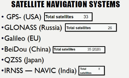
- China said its fully operational home-made Beidounavigation satellite system is ready to provide global services, joining an elite group providing space-based systems comprising the US’s GPS, Russia’s GLONASS and the European Union’s Galileo.
- Experts told Chinese state media that the “…completion of BeiDou-3 was due to the fact that core technologies cannot be bought or begged from other countries”.

NAVIC’S COVERAGE
- It covers India and a region extending 1,500 km (930 mi) around it, with plans for further extension.


BEIDOU (CHINA)
- More than 100 countries including Pakistan and countries part of the Belt and Road Initiative (BRI) are already using the system.
- Chin had to make their navigation satellite system global in order to be independent of U.S operated GPS
ACCURACY
- China’s navigation system uses a network of satellites and can provide positional accuracies of under ten metres (GPS provides positioning accuracies of under 2.2 metres). China initiated BeiDou in 1994 with aims to integrate its application in different sectors, including fishery, agriculture, special care, mass-market applications, forestry and public security.
MILITARY USE AND PROBLEMS FOR INDIA
- China’s People’s Liberation Army has been using the BeiDou satellite system for its various divisions for years for navigation of transport systems and improvement of targeting capabilities for weapons.
- It is the military dimension of BeiDou that is likely to worry Indian strategic planners as Pakistan was the first country to use the system. In 2014, BeiDou set up a network covering Karachi. In 2018, The New York Times reported “Pakistan is the only other country that has been granted access to the system’s military service, allowing more precise guidance for missiles, ships and aircraft”.

IMPORTANCE FOR PAKISTAN
- Pakistani officials have previously said the country cannot rely on GPS during a conflict as the US may restrict availability.
- Satellite navigation is considered a ‘must-have’ for modern militaries for targeting of both nuclear-armed and conventionally armed missiles and bombs. With Pakistan buying a host of major military systems from China—including fighter aircraft, submarines and surface warships—and building its own cruise missiles, its reliance on the BeiDou system is only expected to grow.
Latest Burning Issues | Free PDF


 WhatsApp